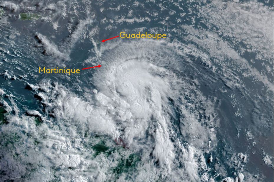
Elsa crosses the Arc of the Lesser Antilles as a Category 1 hurricane.
La Desirade is at greater risk of swelling and sea inundation than the rest of the Guadeloupe archipelago. Hence the fact that the island is placed in the orange vigil, while maintaining the yellow vigil, for the rest of the territory. Elsa is currently at Saint Vincent’s level.
On the morning of Friday, July 2, 2021, the National Hurricane Center (NHC) announced the strengthening of Elsa; Yesterday’s Tropical Storm is now a Category 1 storm.
This phenomenon, moving from west to northwest, at a speed of 44 km / h, is currently crossing the arc of the Lesser Antilles, between Saint Lucia and Saint Vincent and the Grenadines. Barbados was also severely affected by this system.
It is located 300 km south of Guadeloupe.
Guadeloupe predictions
The Guadeloupe, Saint Martin and Saint Barthelemy remain in a yellow vigil, for “Strong winds, sunken waves, heavy rain and thunderstorms‘, except for the island La Désirade, set in the orange awakening Moreover, for bloating and an increased risk of immersion.

On our archipelago, the effects of Elsa lead to the strengthening of the winds, the widening of the sea, and the possibility of exposure to heavy rains, caused by the emergence of spiral bands on the periphery of this phenomenon.
the wind Blows hard in the afternoon, from east, then east to southeast, between 40 and 50 km/h on average, and up to 50 to 60 km/h by sea and on the highlands, with gusts reaching 80 to 90 km/h hour. , up to 110 km / h on relief.
An improvement is expected from this evening, with weak east and southeast winds, between 30 and 40 km/h, then 20 to 30 km/h at the end of the night, a more classic gait.
Let’s calculate the wind gusts recorded at midday on Friday:
- 88 km / h in Belive;
- 83 km / h in Pointe Noire;
- 79 km/h at La Désirade;
- 75 km/h in Gourbert, Gros Morne;
- 72 km / h at Au Raizet;
- 70 km/h at Grand-Bourg.
the sea It continues to expand under the influence of the wind. This resulted in a short east-southeast low-energy swell, engulfing exposed coastlines (3–4 m hollow), with effects mainly in the afternoon through early evening.
Boat anchors will be requested. Unusual waves and a few localized dips can be observed in the lower areas of the coast in the following areas:
– La Désirade, where there is a danger of maritime invasion of some nearby beaches or roads;
– Marie Gallant, especially the east and south coasts;
– Les Saintes, especially the southern coasts;
– north and east of the Grande Terre, from Pointe de la Grande Fiji to Pointe de Chateau;
– South of Grande-Terre, Petit-Cul-de Sac Marin and Côte au vent, from the tip of Châteaux to the Vieux Fort lighthouse.
rainy activity The main part is more concentrated in the south, but the spiral bands that develop around the perimeter of the storm can worry us this afternoon, giving clear showers, with a risk of thunderstorms, leading to large accumulations, in some places. This risk of heavy rain subsides in the evening.
As a reminder, whoever says orange is vigilant, says “Be very vigilant!“.
Cruises, swimming and recreational water activities should be avoided.
Boaters and sailors are welcome to protect their boats, or to wear emergency equipment if they have to stay aboard.
Seashore residents should prepare for the safety of their property, which could potentially be damaged by rising waters or being washed away by the waves.
By car, we must travel cautiously, limiting our speed and not entering roads that are already bulging or flooded.
Forecast in Martinique
Warnings have been issued, in Martinique, but also, indeed, for the southern coast of the Dominican Republic and the entire coast of Haiti, because Avaviola Island in particular will be affected during Saturday.

Most of the islands of Martinique have been put into the orange waking state forStrong winds, sunken waves, heavy rain and thunderstorms‘, except for the exposed coasts to the west and northwest where a yellow decree has been issued.
The island will be affected by the cyclone, which is located 150 kilometers south of the province, until mid-afternoon.
Wind gusts were measured up to 142 km/h, at Vauclin and 130 km/h, at Fond-Saint-Denis.


“Unapologetic pop culture trailblazer. Freelance troublemaker. Food guru. Alcohol fanatic. Gamer. Explorer. Thinker.”
