A study has found that the “glacier of the end of the world” is melting at record speed
⇧ [VIDÉO] You may also like this partner content
Glaciologists reveal that the Thwaites Glacier is melting at an astonishing speed due to warm, high-pressure seawater seeping in several kilometers down its coastal section. It is a complex physical process resulting from direct contact between seawater and fresh water from the glacier. The study results indicate that the Antarctic ice sheet is more vulnerable to rising ocean temperatures than previously thought.
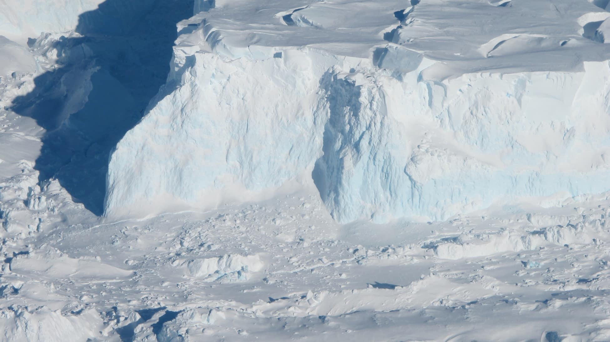
Located in West Antarctica, Thwaites is one of the most unstable and variable glaciers in the world. Its area is about 192 thousand square kilometers (more than four times the area of Switzerland), and it contributes annually to 4% of the rise in ocean levels around the world. Its complete loss would cause sea levels to rise by 3 metres, hence the nickname “the glacier of the end of the world”.
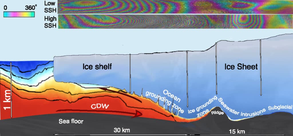
The cycle of seasonal melting and loss of glaciers is governed by a complex process, which is particularly vulnerable to rising ocean temperatures. Part of this process occurs at a boundary called the “anchor line,” located between the “stranded” ice (the part that is floating, but still attached to the coast) and the part floating in the ocean. Stuck ice melts more quickly at its base, the first point of contact with seawater, weakening the entire structure. This is because the freezing temperature of the fresh water mixture of ice and sea water is -1.9
°Celsius, compared to 0°C for fresh water alone. However, rising temperatures are disrupting ocean currents, which push warm seawater toward Antarctica's coasts.
Show a strong climate message 🌍
On the other hand, seawater in contact with the base of the glacier and freshwater generated by geothermal flow and friction accumulate and must flow somewhere. This collected water then infiltrates the ice through natural channels or accumulates in cavities. This creates enough pressure to lift the ice above the water. ” There are places where the water is at approximately the same pressure as the overlying ice. So all it takes is more pressure to make the ice rise », explains in A Press release from the University of California In Irvine (UCI), Eric Regnot. ” The water is then compressed enough to lift an almost kilometer-long column of ice “, he adds.
However, monitoring these dynamic processes faces significant difficulties, largely related to budget shortages. According to Renew, glaciologists even today benefit from the same budget as in the 1990s, so predictions regarding the evolution of the Thwaites Glacier have so far lacked accuracy. ” In the past, we had intermittent data available, and with only these few observations it was difficult to understand what was happening “, He says.
As part of their new study, published in the journal
With peopleRignot and his colleagues have collected the most accurate satellite observation data to date. Their findings suggest that the rate of glacier evolution is underestimated, which may require rethinking models for predicting sea level rise.

A drawing of warm, high-pressure seawater seeping down the Thwaites Glacier. © Eric Rignot et al.
Seawater infiltrates several kilometers beneath the ice
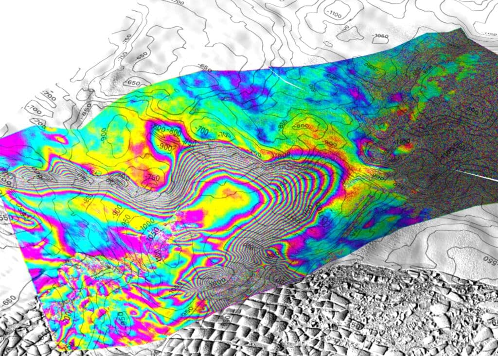
To conduct their investigation, the researchers used data collected between March and June 2023 by the satellite network of the Finnish company ICEYE. The network forms a constellation that hovers over the planet in a polar orbit, allowing, due to the Earth's rotation, to regularly fly over the entire globe. Each satellite has a synthetic aperture interferometric radar, making it possible to precisely track rises and falls as well as the curvature of stranded Thwaites ice. More precisely, it makes it possible to record the movements of its anchor line with daily precision and an accuracy level down to one centimeter.
The researchers found that the glacier's rise and fall cycles were closely coordinated with its tidal cycles. At high tide, seawater seeps in and then gradually flows out from the bottom of the glacier. Sometimes it also happens that it manages to sneak into further places and remains trapped there. Radar data showed that warm, high-pressure seawater can seep several kilometers below the glacier, through channels between 5 and 10 centimeters thick.

3D rendering of the tidal movement of Thwaites Glacier. Contour levels are those of the bed topography at a distance of 50 metres. Each interferometric fringe color cycle corresponds to a 360° phase shift, equivalent to a displacement of 1.65 cm relative to the ice surface. The interferogram is shown on a Landsat 9 image acquired in February 2023. The data show that the bending of the ice varies during the tidal cycle, suggesting that pressurized seawater penetrating beneath the land ice produces a strong heat exchange with the base of the glacier. © Eric Rignot/UCI
However, although they suggest that the magnitude of the effects of ocean warming on Thwaites Glacier is underestimated, the results do not yet allow for an accurate assessment of how quickly irreversible seawater intrusion will occur. However, the researchers believe they will stimulate research in the area to improve prediction models. ” By improving models and focusing our research on these important glaciers, we will try to obtain these numbers at least over decades rather than centuries. », concludes the study co-author Christine Dow, from the University of Waterloo, Canada.
source : With people

“Incurable web evangelist. Hipster-friendly gamer. Award-winning entrepreneur. Falls down a lot.”
